GIS, Aerial Mapping, Data Management and Analysis
Meridian staff use a variety of tools and methods to prepare technical analyses and make resource management recommendations to our clients. We use ArcGIS software to evaluate geographic-based data and identify spatial relationships between features on the ground. Other data management tools used regularly include Microsoft Excel spreadsheets and Access databases. Meridian is equipped with a small Unmanned Aircraft System (sUAS, UAV, or drone) for field deployment to produce high-resolution aerial photos, photogrammetric surveys, and video of projects. We have developed analytical methods that integrate multiple tools that allow us to evaluate large data sets, such as for hydrology or water quality. We also regularly translate and transfer data between different tools (such as between GIS and Access, or between Access and Excel) to take advantage of the most efficient analytical techniques.
Tongass National Forest Rare Plant Surveys Data Management
US Forest Service, Region 10 
Meridian designed three MS Access databases
with graphical interfaces for field data entry
computers. Two databases (Survey Sites and
Element Occurrences) mimicked the data
structure of the Forest Service Natural
Resource Information System (NRIS) to ensure
the seamless transfer of data to the NRIS
database. The third database was created to
provide an electronic record of all species
encountered at all survey sites. Data entry
screens were designed to have a similar look
as the hard copy data forms used in the field
and used lookup tables and validity checking
to reduce the probability of data errors.
Common names, Latin names, and codes for all
plant species were imported into the databases
from the NRIS and used as lookup tables. This
approach prevented errors that could result
when entering plant names, and ensured a
consistent set of names between field
computers and the NRIS.
Swift No. 2 Hydroelectric Project Water Temperature and TDG Data Analysis
Cowlitz County PUD 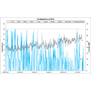
Over a 10-year period, Meridian's biologists
collected hourly water temperature and total
dissolved gas data in the project power canal,
surge arresting structure, and tailrace. Data
were downloaded monthly and compared with
generation data stored in the Project's SCADA
system. Results of these analyses were used to
evaluate compliance with existing state water
quality standards and other Section 401 Water
Quality Certificate requirements.
Henry M. Jackson Hydroelectric Project Riparian and Aquatic Habitat GIS Mapping
Snohomish County PUD
Meridian assessed riverine, riparian and
wetland habitat on approximately 10,000 acres
along a 16-mile reach of the Sultan River to
quantitatively analyze and spatially represent
the types and amounts of habitat available for
fish, amphibians, and terrestrial species. We
compiled and reviewed aerial photos, LiDAR
imagery, and existing cover type mapping;
developed an integrated vegetation
classification system that maximized use of
existing information; field-verified the
classifications and mapping; and integrated
the final product into the client's GIS data
structure.
Tongass National Forest Rare Plant Surveys GIS Analysis
US Forest Service, Region 10 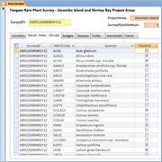
Meridian used soils, vegetation, hydrology,
geology, and terrain data from the Tongass
National Forest GIS library to identify
landscape features with a high probability of
finding target survey species. The GIS
analysis was combined with stereo aerial photo
interpretation and previous on-the-ground
experience to identify microsites containing
unique habitats that were selected for
targeted surveys. GIS data was also used to
prepare field maps identifying survey areas
and site access. All survey routes were
recorded in the field using GPS tracking and
documented on GIS reports.
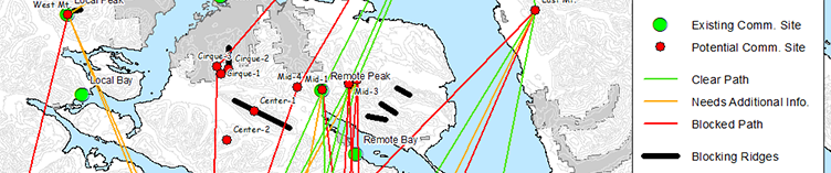
Southeast Alaska Microwave Network GIS Analysis
AP&T Wireless, Alaska 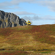
Meridian conducted GIS analyses to identify a
feasible route between Juneau and Sitka for
transmitting microwave communication signals.
Topographical features, land use designations,
microwave signal transmission constraints,
maintenance access, and site engineering
design parameters were used to identify
locations for potential new communication
towers. GIS analysis was conducted for 25
sites and all possible microwave signal paths
between sites to identify a handful of
feasible locations for field evaluation.
Meridian staff led an engineering
reconnaissance survey by helicopter to verify
the feasibility of selected sites.
Cowlitz Large Woody Debris Monitoring Database
Tacoma Power
Meridian designed field sampling protocols and
data analysis tools to quantify the
distribution and quantity of large woody
debris in the Cowlitz River below Mayfield
Dam. Our statistical sampling techniques and
database tools have ensured a consistent
analysis and reporting of data between
sampling periods. The large woody debris
monitoring program is being used to evaluate
the effect that collecting large woody debris
in the reservoirs and distributing it to
downstream locations has on aquatic habitat.
California Hatchery Scientific Review Group Technical Maps
Pacific States Marine Fisheries Commission
and US Fish and Wildlife Service
Meridian created new GIS mapping layers to
document the location of structures and
facilities to monitor anadromous salmon
populations within the San Joaquin,
Sacramento, and Klamath River watersheds.
Meridian also prepared maps to display all
fish management structures, facilities, and
release sites within the watersheds for the
science team to assist with visualizing
alternative fish management policy decisions,
and maps for the reports distributed to
federal and state agency managers.